Logo for Overlook Mountain Center
A New York State Non-Profit 501(C)3 Educational Corporation 

Researching Archaeoastronomy and Landscape Archaeology in Northeast America and Beyond
Preserving and Protecting   
Environment – Culture – Community

Mysteries of Lewis Hollow

Historic Marker

Lewis Hollow Research

Manitou Ashenal (spirit stone)

Serpent effigy

Petroform Map

Lewis Hollow Map

Constellation Draco

Draco vs Petroform

Thuban - Once the Pole Star

CELEBRATING our 10TH Year!

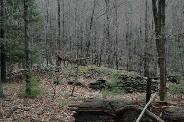
Stewarding a Manitou Hassennash (Spirit Stone) preserve in Woodstock, NY.

From 10 years ago, this video shows the birth of OMC’s ultimately successful effort to protect lands in Lewis Hollow on Overlook Mountain 
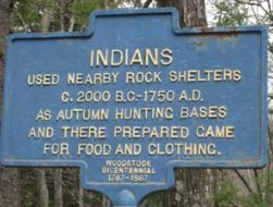
Identifying, documenting and protecting Native American Ceremonial Stone Landscapes (CSL) as Important Resources of Cultural Significance.
          “Let the Landscape Speak”                  ~ Doug Harris  – Dep. Tribal Historic Preservation Officer (THPO) Narragansett Indian Tribe of Rhode Island (retired) 

Essays & Writings

Danskammer Addendum adding to earlier research by Glenn Kreisberg and others. 

Most historic rivers have had their shores, banks, points and inlets well documented by researchers and those interested in understanding land use and property ownership throughout historic times. Of course, any river’s story in America is much older than the towns and industries that have been established and recorded since Europeans arrived en masse, in the late 17th century. 

One of the earliest, if not the earliest, documented land locations recorded in our region is Danskammer Point along the west shore on the Hudson River, a little north of Newburgh. This paper will attempt to trace the property ownership of Danskammer Point, from when it was first identified as a Native American ceremonial site, by Henry Hudson on his third voyage of discovery seeking a northwest passage, in Sept, 1609, up though present time. 

Thanks to the work of previous researchers, and the digital age we live in, resources are available for the layman to discover many details about the “chain of custody”, so to speak, of Danskammer Point. The tools available for such an endeavor include: Newspaper archives, Property Cards, County Real Property Tax records, Historical Society materials, and online services such as the Hathi Trust, among others.

According to tradition, originally named as The Devil’s Dance Chamber (Duyvil’s Danskammer in Dutch), by the crew of The Half Moon, it wasn’t until 1640 that the location name was publicly referred to as such by David Peterz de Vries.

Land ownership records are created as land is bought or sold, or handed down from generation to generation, when transfered through inheritance. So, to trace the land sales and transfers, you must first track down the land owners, land sellers and land buyers, and the associated transaction records. Many times it’s an exercise in genealogy, discovering who married who and who gave birth and who past on. Often these were the events that dictated the sale, purchase and bequeath of inheritance (including wealth, debt and property). 

In general terms, land acquisition began with Kings granting land patents and manors to their agents in the field, who worked on the crowns behalf acquiring new territory. Manors were granted to individuals (think Livingston Manor) and Patents were granted to groups of associates. Land acquisition for Grants and Patents from local Native Americans was most commonly accomplished through traditional means of pressure tactics, with negotiations typically involving manipulation, intimidation, trickery, all in the name of land and resource conquest for the Crown. It’s interesting to note that language still exists in the NY State constitution that prohibits the forfeiture of lands originally acquired through Manor and Patent grants.

This paper will start in the present and offer a narrative supported by evidence, working backwards through time, establishing a chronology of ownership for the property known as Danskammer Point, SLB 8-1-78.2 52 acres, on the Orange County NY tax roles. 

Parcel tax map for Orange County

There are multiple parcels which make up the Danskammer Point power generating plant. Many have changed hands multiple time in recent years, however the main parcel that makes up “the point”, is still held by Central Hudson Gas & Electric, the 52 acre lot SLB 8-1-78.2, which borders the river.

Orange County parcel tax map for Danskammer Point parcels.

Some of the recent, somewhat convoluted, transactions involving other Danskammer parcels between 2001 – 2018 include:

Danskammer Energy is recorded 2018 – present. Dynegy sold the plant to Helios Power Capital, LLC in 2013, who in turn sold it to Mercuria Energy Group; Mercuria sold it to Tiger Infrastructure, a private equity firm based on 5th Avenue in New York City. 

Orange County GIS satellite map showing parcels boundaries. 

Lot SLB 8-1-78.2 listed ownership is Central Hudson Gas & Electric 1948 – Present. 

Nancy Armstrong (1915 – 2010), was the most recent Armstrong to hold the property, prior to CHG&E. Some accounts say originally, the land was given as a gift to the Armstrong family from George Washington, for the family’s support during the Revolutionary War. See below.

David Maitland Armstrong (1836 – 1918), whose father Edward Armstrong, (1800 – 1840), was a farmer who bought 1000 acres in 1822, from the Wolvert Ecker estate, which was in foreclosure. This purchase included two miles of frontage along the Hudson from Roseton to Cedar Cliffs, including Danskammer Point. Edward built an opulent mansion that was later demolished for the clay soil beneath it. Edward was the son of Col. William Armstrong (1750? – 1830?), a British officer from Scotland, who negotiated the surrender of the British to George Washington under truce, at Newburgh in 1782.  

One can’t help wonder if part if the civilized negotiations included Armstrong ending up with Danskammer Point and the surrounding farm lands. So, how did a British officer (on the losing side) end up with such a war spoil and how was it Washington’s to give away?

What were the circumstances and terms of the foreclosure sale to Edward Armstrong, son of William, from the Ecker heirs? There’s probably much more to the story.

Wolvert Ecker (1730-1799) bought the point on 1/13/1772 (prior to the Revolutionary War), for 846 Pounds, at foreclosure auction by Ulster County and retained the land for 50 years, until the foreclosure sale to Edward Armstrong in 1822. It appears Jacobus van Blarcken, the landowner of record prior to Ecker, was foreclosed on for tax delinquency in Ulster County in 1771 or before. 

At the time, Danskammer Point was part of Ulster County. In 1798, the southeastern portion of Ulster County became Orange County, to even things out, after the most Southern portion of Orange County became Rockland County. Call it the county lot line revision of 1798.

Danskammer Point was in the northern most portion of the Harrison Patent. 

Sale to Luis Moses Gomez (1660 – 1740) an early Jewish settler who in 1716, purchased 1200 acres with river frontage, expanded to 3000 acres by 1723. (Includes the point?)

Jurian Mackey (1725 – 1803) acquired 600 acres of the Patent from Susanna Bond, referred to as “Dam’s Commer”, which Susanna Bond inherited from father William Bond. Capt. William Bond was a 1714 George Harrison Patent holder. 

Harrison Patent was 5600 acres granted in 1714 by King George III. Prior to that, the land would have been a Lenape Native American possession, per tales of incidents from subsequent witnessed ceremonies witnessed by Peter Stuyvesant, to an Indian guide kidnapping, killings and ransom of a captured colonial woman traveling with her husband from Albany to New Amsterdam. 

A lot can be inferred from these facts, though some things may never be known. These unknowns may be represented in the apparent inconsistencies and discontinuity of some of this chronology. And, there are still question to be asked and answers to be sought about how this sacred Native American ceremonial site fell victim to dispossession and oppression in the colonial and early American eras, and may speak to wrongs still waiting to be righted. 

Aside from a tiny indigenous collection at the NYS Museum in Albany, from Mary Butler Lewis (1903–1970) America’s first woman archaeologist, taken directly from Danskammer Point (82 artifacts in total), there’s not much else documenting the site. Any physical evidence of Native American presence on Danskammer Point has long been obliterated by the industrial footprint of the modern era, and the early American and colonial era footprints that came before. Yet, the site location itself, and the locations relationship to the surrounding landscapes and skyscapes, still stands in silent testimony of the Native American presence there. Additionally, to this day, some of the most fertile lands found anywhere, lay upslope from Danskammer Point, on the southeasterly facing farm fields and fruit orchards found in Milton and Marlboro.

It has also been shown that Danskammer Point has an important relationship with the mouth of Wappinger’s Creek, across the river and slightly north. On the morning of the summer solstice, the longest day of the year in the northern hemisphere, the sun as seen from Danskammer Point, aligns on the northeast horizon with the mouth of the creek. This archaeoastrological alignment may speak to the significance of Danskammer Point as a ceremonial site for the Munsee speaking Lenape, whose ancestors occupied the region for millennia.  

It may also represent a direct and tangible connection to their ancestral land, sacred still to this day, yet lost to them for centuries.  

Google Earth 3D map showing summer solstice sunrise over Danskammer Point

Maps showing Danskammer Point azimuths relative to the mouth of Wappinger’s Creek. 

It’s interesting to note that the property has an ownership history associated with foreclosures, as the early private landowners, van Blarcken and Ecker, were apparently unable to secure their equity in the property. Yet now, and since converted to an industrial site in the mid 20th century, huge profits have been realized for the corporate owners and shareholders. Where is the equity in that for Indigenous tribes who lost their sacred lands without agency, consultation or consent? Perhaps it’s not too late for that equity to be established and achieved for those who lost so much, while others gained and garnered wealth and power, from that loss, for all these years. 

References 

https://househistree.com/houses/danskammer


https://www.hathitrust.org/

https://cdm16694.contentdm.oclc.org/digital/collection/newburgh/id/867/

https://www.gomez.org/about.html

https://freepages.rootsweb.com/~woolsey/genealogy/resources/deeds/deeds_ulster_co_ny_roads.htm

https://dan-keller.com/danskammer.html

https://www.gutenberg.org/ebooks/6615

https://gis.orangecountygov.com/orange/

https://propertydata.orangecountygov.com/viewlist.aspx?sort=printkey&swis=all&printkey=8-1-78.2

https://www.academia.edu/29943760/Ancient_Astronomy_Along_the_Hudson_River_in_New_York_State


Waghkonk Notes by Dave Holden

WINTERMARC March 2022

Snow-devils spin their spritely dervish-dance, winds rage across the suddenly-winter landscape, snow and sleet pelt the window-panes, brown leaves skitter helplessly across rapidly shifting snow-dunes to fly up against tree-boles plastered in wind-blown whiteness. Branches bend and break, shedding the weak or old. Whole trees bow deeply down in obeisance to the power of the arctic Winter-king as we are all reminded of his bitter-cold might (just in case we had forgotten). The small-birds are the only ones to brazenly venture forth. All other creatures (us included) hunker down to wait out the snowy onslaught, huddled closely together in primeval awe (and possibly raw, unutterable fear) of the incredible power of our sometimes still-wild world. Maybe this is a good thing, to be reminded of how really small we are in the scale of the universe.   


THE ICE-STORM – As northeast winds howl through the Catskills and Hudson Valley, and the Lady re-dons her snowy mantle, almost all vestiges of what once seemed like an early vernal season have been mercilessly and rapidly buried under icy winter-white. I (and others) have aptly used the “rollercoaster” analogy to describe this winter’s back and forth confusion, alternating warmth and cold. Well, evidently the ‘coaster stopped and not at a Spring-y location. Nope, as everyone reading this readily knows, it came to rest in a very wintry place – most intensely so in the early hours of Friday, February 4th in the form of a devastating and widespread ice-storm which knockout out power for most residents of eastern Ulster County, some for many days. Not only unprecedented in its scale, locally, but in duration of its effects, as well, as ice stayed on the trees for several days. Initially, even in the black-out that followed, the glittering ice was beautiful, subject of many photos, but quickly got very old. Thank goodness there was no high winds after the storm subsided or the effects could have been even worse. We will be dealing with the after-effects of this for many months, maybe years, because the storm was like a giant shredder in the woods. There was already many blowdowns and much accumulated underbrush still in the forest from not-so-recent hurricanes and nor’easters, which alone has created a potentially dire future forest-fire danger. Now, due to this one single event, there are many, many more branches and downed trees littering the forest floor, as well as tons of widow-makers suspended high above. Amazing.  

CRAZY MONTH – Crazy, indeed – just when we all thought the trend was toward Spring – the days are noticeably longer, more and more migrating birds have returned ready to mate; numerous small plants, shrubs and trees had started to poke up their green shoots or branches to bud, but Nature evidently runs on its own cycle. Just because we mark time with our silly calendars and make exhaustive notes of the “signs of spring”, the earth is not constrained in any fashion. It is probably not concerned with us. That may deeply disturb many people who have been raised to think how powerful we are, that the earth somehow revolves around our tiny little selves. On top of all that, climate-change is rea
l and is contributing greatly already to drastic changes that we (and the earth) are experiencing. That being said, and even taking into account what an (obviously) crazy month March can be, Spring is still “just around the corner” (exactly which corner, I don’t know). I can see the effect that the higher sun-angle adds to the longer days on our recent white “blizzard-gift”, encouraging more – and more rapid – melting than we would experience in the shorter days of mid-winter, but we may still have snow left on the ground on the first day of Spring, Sunday, March 20. Days like these – like our devastating Ice Storm of February 2022 – all of us at the mercy of the elements – serve to remind us of things that we’d rather forget – but never should. Events like this ice-storm should serve to remind us to try to be prepared – for whatever life/nature throws our way. We should always have a full pantry, so we don’t have to panic at the advent of a storm, which can sometimes be quite sudden. Having a back-up heat source is also extremely important. Sounds obvious, but it is surprising how many don’t take it seriously until it is too late. We need to drive slowly and to steer into a skid. Try to keep your gas-tank full and have a blanket, gloves and hat in the vehicle. In the woods in the winter always carry a light in case of the onset of darkness and dress appropriately, wearing your gloves or mittens and a hat. Again, I know much of this sounds like common sense (it is), yet many need to be reminded. It is not uncommon for me to see people walking up a trail in winter dressed in street-clothes, with just light hat, gloves and jacket. People are always surprised how fast it can get cold once the sun sets. Re: footwear – I can’t emphasize enough how important the right boots can be, particularly with spring thaw coming (yes, it will happen). I put it that way because without the right shoes people have a tendency to walk around muddy spots, thereby going off the trail and possibly damaging delicate endangered plants-to-be, still buried just off trail, and making the trail-keeper’s job more difficult. Remember – wear the right shoes and walk through the mud.
FAUNAL FLORA – Tough time for White Tail deer – with snow either too deep to walk in (if above their knees, deer have a tendency to break their legs) or if too icy, and they can’t feed, white tails “yard up” in deer yards, in among the pines. I wonder – do the deer, all huddled together tell stories about other storms? Are the younger ones more scared than the older ones, as the mad winds race through the trees, pelting, stinging them with wind-blown snow? They have excellent hearing – are they extra-sensitive to the howling winds? Do they post sentries to keep a lookout for coyotes? It’s rough weather now for Wild Turkeys, also – not enough browse for them and they also become more vulnerable to the predations of Eastern Coyotes, as well, who will take advantage of the turkey’s clustering together in the shelter of hemlocks and pines.

WINTER/SPRING
As you can tell, I love Spring (who doesn’t?). The only issue I have with it is that it takes seemingly forever for it to come to fruition. I know I’ve said it before, but all of the other seasons fairly zip along, whereas spring always seems like it takes forever. For one thing, with March as an example, early spring is really hard to tell from late winter. At this moment, we’re still apt to get below freezing and have snow. It is some consolation to know that it will not last on the ground as the angle of the sun is higher and the surface is considerably warmer than it had been, yet it always frustrates us (“We want spring and we want it now!”). Maybe it would help if we made four minor seasons to connect the four major ones – Winterspring, Summerspring, Summerfall and Winterfall – to each other. Then it might be easier to adapt from one to the other. Still, I think Spring will always suffer from our green expectations after so long without verdure. It’s probably only “psychological” (either that or it’s all in our heads) because we need the green of life so much now after (seemingly) going so long without it. Well, as everyone likes to say, finally “the light is at the end of the tunnel” and getting closer every day. Hang in there all
Thank you all for your continued encouragement and support. Let’s try to enjoy this late-winter landscape, but please be safe in doing so and I also suggest that we try to be extra-considerate of each other in this time. Please drive, snowshoe, ski or walk in a mindful fashion, being aware of others – and the earth – around us. Thanks again.
Take Care, “Ranger” Dave Holden   More from Ranger Dave click here


The Devil’s Dilemma

by Glenn Kreisberg – as appears in the Mountain Top Historical Society (MTHS) Fall 2019 Newsletter.

The Devil’s Tombstone, an impressive monolith off Rt. 214 between Phoenicia and Hunter, New York reminds us to keep an open mind to the prospect of archeoastronomy and landscape archaeology in our region. The glacial erratic stand staunchly upright, protruding vertically from the ground like a giant gravestone. Geologists tell us it was placed this way, dropped out of a glacier as it was receding after the last glacial maximum some 20,000 years ago. I happen to believe other factors were at play since then, to get it to where we see it today. I’ll call it the human factor; that humans played some part in the movement and placement of the Devils Tombstone monument. If so, then perhaps the Devils Tombstone should be seen not only as an object of geological interest but one of cultural significance as well.

But first, a quick lesson on the Hammonasset Line, identified by some researchers as a winter solstice sunrise, summer solstice sunset alignment between the Devil’s Tombstone and Council Rock, at Fort Pond on eastern Long Island, used for endless generations as a meeting spot of the Montauk Tribe.All along this “line”, as it extends from Long Island, across Connecticut and into our region of NY, are found numerous Manitou achsinal (Munsee) or “spirit stones”, man made stone constructions considered scared by the indigenous tribes of the northeast. That the alignment between these two well know stone monuments runs on a bearing from 137 deg. (mag.) in the southeast, to 317 deg. (mag.)northwest, is objectively determined with protractor, map and ruler. That these azimuths or points on the horizon, match closely to where the sun rises and sets on the longest and shortest day of the year (the solstices), is also simply a matter of math. If that is a matter of coincidence or intention, is at the heart of what many find so fascinating about this mystery.

The Devil’s Tombstone monolith in Stony Clove

Now back to the Devil’s Tombstone. Is there evidence suggested in the name itself, that ancient indigenous people in our region help in erecting the Devil’s Tombstone? Other sites in our region have Devil in their names. Examples include Devil’s Acre, Devil’s Kitchen, the Devil’s Dance Chamber (or Danskammer, in Dutch). Many of these names were given by the first Europeans in the region, theDutch who were among the first to settle Catskills. To the Dutch Calvinists, the Native American tribes that inhabited our region were Devil Worshipers, thus the names of places Indians carried out their religious ceremonies were attached the Devil’s name. This is best documented by the crew of Henry Hudson’s Halfmoon, on Sept. 9th1609, on Hudson’s 3rd voyage of discovery.  Upon seeing a large native ceremony taking place on a prominent point of land on the western shore of the river they were sailing up, they gave it the name, still used till this day,Danskammer Pointor the Devil’s Dance Chamber, found north of Newburgh on the Hudson River (you can find it on Google Maps). It turns out that Danskammer Point has an important relationship with the mouth of the Wappinger’s Creek, across the river, on a solstice sunrise/sunset alignment, not unlike the situation with the Hammonasset Line and the relationship between Devil’s Tombstone and Council Rock on Long Island. Coincidence?

When we find patterns we were not looking for, it calls for attention.  So, if the claim is made that the Devil’s Tombstone has a purposeful orientation, related to the solstices, are there other stones in its vicinity that also possess those or similar features? It turns out there are two, both within 1 mile of the Devils’ Tombstone.  The first in located on the path from Notch Lake in Stony Clove, heading up Plateau Mountain, on the DEC trail. About ¾ ways to the north western summit, sits a medium size, unassuming boulder alongside the trail known as Plateau Mtn. Calendar Stone I, first reported in a NEARA Journal article by Gary Jaycox in 1981. The second, Plateau Mtn. Calendar Stone II, located across the summit ridge to the east, and oriented to the winter solstice sunrise, is replete with inscriptions and an old glyph related to the Sun.

Two “Calendar Stones” have been identified and documented on Plateau Mountain, above Stony Clove and the Devils Tombstone.Both stones and their locations lay on or near what’s known as the Hammonasset Line. That these stones are found in the vicinity of Devil’s Tombstone, suggests a connection between the monuments and a consistent pattern of evidence that supports the ideathey are all important resources of cultural significance, connecting earth with sky from a time long past. If so, the implications are fascinating to contemplate.

Plateau Mtn. Calendar Stone II, on Plateau Mtn. SE summit.


Water, Rock and Sky – Elements of a Three Dimensional World View

Lewis Hollow update – By Glenn Kreisberg – June 10th, 2018

As absurd as it may sound, a comparison of the Lewis Hollow Site on Overlook Mountain in upstate New York and the temple complex of Ankor Wat in the jungles of Cambodia reveal some remarkable parallels. These parallels illustrate how a similar, sophisticated “worldview” may have indeed been just that; a universal belief system and practice, shared by ancient cultures around the world and across the globe.  Do we see evidence of this in the unlikely commonalities found between these two sites?

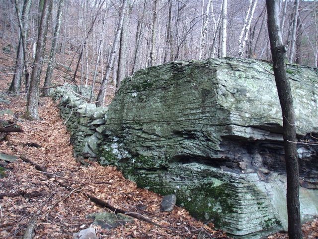
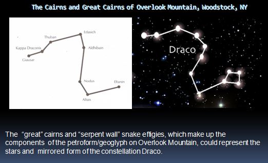
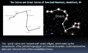
It has always been a confounding mystery to me how both the stone constructions at the Lewis Hollow site on Overlook Mountain and the Ankor Wat stone temples in the jungles of Cambodia both seem to mirror the northern circumpolar constellation Draco. This was shown to be true in my research on the Lewis Hollow site in Spirits in Stone and in Graham Hancock’s book Heavens Mirror.  That connection was of course quite unexpected, as was the discovery of the Draco petroform on Overlook Mountain, in the first place.

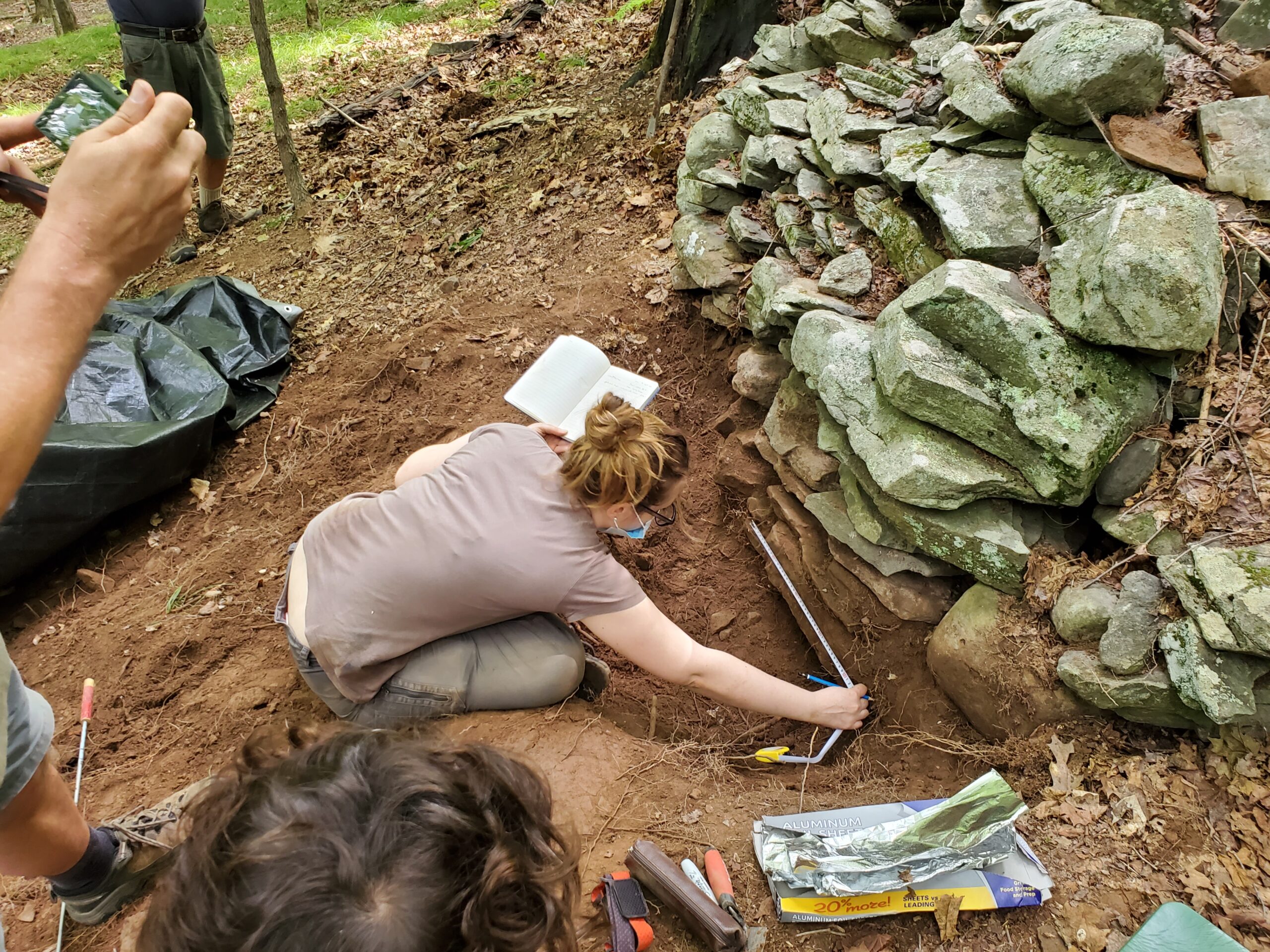
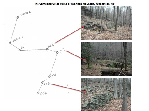
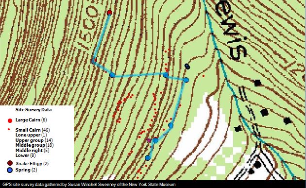
It wasn’t until very recently that I began to realize the connection did not end there.  In the work of David Johnson at the Lewis Hollow site, it was shown through his dowsing surveys of the subsurface groundwater flow, that the stone constructions on the surface, the cairns, “great” cairns and serpent effigy walls were also marking and mapping the subsurface water features, where the ground water flowed more easily through the fractured bedrock to feed springs below.  Those year round springs, along with the intermittent surface flow of rainwater in the steep hollow, feed small local brooks and streams that flow into larger creeks and rivers. But perhaps more was going on than just mapping the locations of the important headwater sources. Maybe there was more intention and purpose involved.

Recent studies have revealed how the ancient Kumar culture in Cambodia used ground water to both sure up the foundations of their massive temples and provide irrigation for their agriculture. They built large moats around the perimeter of their temples which would fill in the rainy season and slowly drain into the surrounding ground to help solidify the sandy soil beneath the temples and create cement-like foundations to prevent the structures from crumbling.  Also, while these moats were slowly draining, during the dry season, their stored water was diverted into distribution canals to flood nearby fields to grow rice, which requires two inches of standing water.

At the Lewis Hollow site we also see how understanding and controlling the groundwater was part of the plan, but why?  Is it possible there was a ceremonial and perhaps agricultural component to the manipulation of the landscape to map the subsurface hydrologic features in Lewis Hollow? It’s interesting to note the location of the Zena cornfields, a known Native American agricultural site in very close proximity to Lewis Hollow. In fact, if you draw a straight line along the axis of the hollow, out of the mountain, it leads directly from Lewis Hollow to the Zena corn fields located directly below the hollow, on the landscape. As water likes to follow the path of least resistance, it’s reasonable to see how the ground and surface water gathered and collected up in the Lewis Hollow springs and streams would seep and flow downward and end up feeding the Sawkill River, which runs parallel to the Zena cornfield to the west, or recharging the aquifer beneath the ancient cornfield on the valley floor.

As the two old spring houses located up in Lewis Hollow attest, people have always sought to utilize the waters coming off Overlook Mountain into Lewis Hollow. Remnants of old homeade piping systems still exist, leading from those spring houses, transporting water to properties located in the lower parts of the hollow. Could the ancient Native American population of the area have wanted to help direct that water to their agricultural endeavors in the fields further below? Could the field itself have been located on the valley floor directly beneath the mouth of hollow in the mountain, where the water was concentrated and gathered? These are questions worth asking and understanding.

Now, I’m not saying ancient Cambodians visited North America. The Ankor Wat temples date from about 1000 years ago, and some of the Catskill Mountain cairn complexes are speculated to be at least 3000 years old, and obviously more primitive expressions than the Kumar temples. Given that, when applying the concepts of cultural diffusion and early transoceanic peopling of the continents, over great time and distance, who’s to say, and one might wonder who influenced who?

Nevertheless, by identifying the similarities between the Lewis Hollow and Ankor Wat sites, we can ask if the ancient Kumar and the ancient Native Americans shared a similar three dimensional world view, where sacred water (from the underworld) linked with their stone constructions on the earth’s surface, (the world of the living), and which in turn relate to the celestial or supernatural world above and specifically in this instance, the constellation Draco in the night sky?  One must believe there’s more to the story than mere coincidence; a representation that may reflect an ancient global view of our human place in the Universe.

Is there a relationship between the location of the Native American corn field in Zena and the water source in Lewis Hollow on Overlook Mountain?

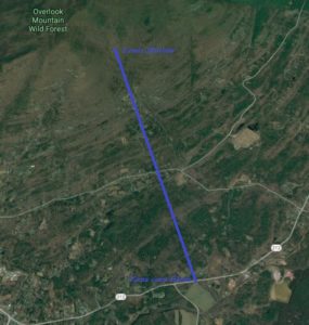
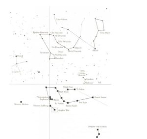
Ankor Wat temple locations in Cambodia (below) compared to the northern constellation Draco (above)


Overlook Mountain Draco petroform in Lewis Hollow compared to the northern constellation Draco

References

https://ancientwatertechnologies.com/2015/05/21/water-technologies-of-the-khmer-civilization-angkor/

https://grahamhancock.com/kreisbergg5/

Biography

Glenn Kreisberg is an author, outdoor guide, and radio engineer, who researches archeoastronomy and landscape archaeology in the Hudson Valley and Catskill Mountains of New York. His books include Mysteries of the Ancient PastLost Knowledge of the Ancients, and Spirits in Stone. He served two terms as vice president of the New England Antiquities Research Association (NEARA) and studied archeoastronomy at SUNY and archaeoacoustics on Malta. He is co-founder of the non-profit Overlook Mountain Center (www.overlookmountain.org) in Woodstock, NY, where he lives with his wife and two teenage children, a dog, three cats, a bird, a lizard and a fish.